与「GeospatialAI」相关的搜索结果
GeospatialAI 贴吧
一个关键词就是一个贴吧,路径全站唯一。
用户
未找到
包含 GeospatialAI 的内容

Your best Gaussian Splat might already be sitting in your Scaniverse account.
The #SplatYourWorld# Challenge is open through July 31. Submit your best capture for a chance to win a share of $4,000 USD in prizes.
We're looking for standout 3D reconstructions of:
🏭 Industrial environments
🌲 Natural landscapes
🏙️ Urban infrastructure
No need to create something new—just submit your best Gaussian Splat and put the prize money toward new gear, more captures, or whatever powers your workflow.
📅 Deadline: July 31, 11:59 PM PT
Learn more:
#NianticSpatial# #3DReconstruction# #DigitalTwins# #PhysicalAI# #GeospatialAI# #AI# #3DGS#
显示更多


Forecasting where a disease outbreak might spread usually requires weeks of stitching together fragmented satellite imagery, census tables, and local health records.
Now, new research shows how Google Earth AI can help communities address public health crises more quickly and proactively.
By combining insights beyond simple statistics — like behavioral trends, geospatial AI models, and more — public health teams can better understand complex public health issues, bridge reporting gaps, and shift emergency response from reactive management to proactive prevention.
显示更多
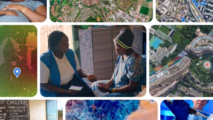
During the ongoing Ebola outbreak in the Democratic Republic of Congo (DRC), our partners at @WHOAFRO put Google Earth AI to work to uncover transmission blind spots faster.
They used our Geospatial Reasoning agent prototype to map areas where exposure risk and human mobility are high. In minutes, the team pinpointed 48 exposed settlements and located more than 45,500 at-risk people — a process that normally would have taken weeks.
显示更多

Google Earth AI can bridge critical gaps across diverse geographies, diseases, and areas of public health using autonomous predictions and population dynamics.
The system combines environmental signals and other data sources with AlphaEarth Foundations and our Population Dynamics Foundation Model (PDFM), and a prototype Geospatial Reasoning agent.
In plain language, researchers ask questions like where a disease is likely to spread next, and the AI automatically gathers relevant models and datasets to build an accurate prediction model.
By combining satellite views with population patterns, the tool reveals hidden risk factors, helping identify issues earlier.
显示更多


ELEMNT turns raw geospatial data into a live map in 3 steps: import in open formats, generate PMTiles, serve through OGC API Features. No tile servers to run, no lock-in, and your data stays portable.

GeoLibre v2.3.0 is here!
GeoLibre is a free and open-source, lightweight, cloud-native GIS platform for visualizing, exploring, and analyzing geospatial data. It runs everywhere you do, in the web browser, on the desktop, on mobile, and inside Jupyter notebooks, all while keeping your data local and private.
This release brings a legend that writes itself from your symbology, a new GeoLens catalog browser, and 200+ GeoLibre Rust geoprocessing tools running entirely in the browser.
What's new in v2.3.0
- Automatic on-map Legend: the legend builds itself from your visible layers, with class rows for graduated, categorized, rule-based, and expression styling, gradient bars for heatmaps and raster colormaps, and land-cover labels from a Raster Attribute Table. Rename, hide, reorder, or add your own entries, and it saves with the project.
- Symbology swatches in the Layers panel: every row shows a dot, line, square, or image glyph in the layer's own color, so a tall layer stack reads at a glance.
- GeoLens catalog browser: connect to a self-hosted GeoLens server, search its catalog, and add datasets as vector tiles, GeoJSON, or rendered raster tiles.
- Emerging Hot Spot Analysis: build a space-time cube from timestamped points and classify every cell as a new, intensifying, persistent, diminishing, sporadic, oscillating, or historical hot or cold spot, all client side.
- Mosaic time series: the Time Slider now steps through MosaicJSON and STAC collections of many COGs per date, on either a GPU or a WASM rendering engine.
- Copy and paste layer styles: give a whole set of layers one consistent look without restyling each in turn.
- Shareable tool links: deep-link any Whitebox tool with a ?tool= URL that opens the dialog preselected and pre-fills the form, with a Copy link button to build it for you.
- Smarter data loading: pick which layers to load from a multi-layer GeoPackage, import CSVs whose coordinates are in any projected CRS, and read a raster's real CRS, pixel size, and extent from the metadata dialog.
- Multiple AI profiles: define several provider, model, and credential setups, pick a default, and switch between them from the assistant panel.
Try it out
- Launch GeoLibre Web:
- GitHub:
- Documentation:
- Release notes:
#GIS# #Geospatial# #OpenSource# #RemoteSensing# #MapLibre# #GeoLibre#
显示更多


Converting flat satellite maps into fully interactive 3D digital twins used to take weeks of manual 3D modeling and GIS engineering
Now, a single tool can process geospatial satellite data and reconstruct the complete 3D geometry of any building on Earth in seconds
Here is how the spatial extraction actually works:
First, you select a structure on a standard satellite map.
The software reads the footprint, elevation data, and height boundaries
Next, it automatically generates a volumetric 3D wireframe mesh, rendering the physical layout in real time
From there, you can apply a cross-section slice to cut through individual floors, revealing subterranean basements and foundation depth
Finally, you can drop into a first-person view to physically navigate interior corridors, stairwells, and room layouts
This bridges the gap between static geospatial map data and immersive 3D spatial simulation for architecture, urban planning, and spatial analysis
显示更多


#DePIN# Leaders Just Dropped $43.74M in 30D Revenue
($12.35M) & #Helium# ($12.20M) dominating as real-world infrastructure turns into real cash on-chain. Decentralized compute, networks & geospatial the #tokenization# of physical assets is here.
This is the backbone of #Web3#.
显示更多
